
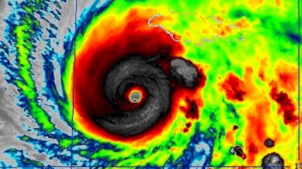
Fueled by exceptionally warm Caribbean ocean temperatures, Hurricane Melissa escalated into a Category 5 cyclone while advancing at a pace barely exceeding a leisurely stroll. This perilous combination has the potential to intensify its destructive impacts through persistent precipitation, elevated storm surge, and formidable winds.
Scientific consensus indicates that both rapid storm intensification and prolonged stationary periods are becoming more prevalent within an evolving climate landscape. The following provides essential insights into these phenomena.
Accelerated Power Due to Climate Change
Melissa underwent a dramatic transformation, progressing from a tropical storm boasting 70 mph (110 kph) winds on Saturday morning to a 140 mph Category 4 cyclone within a 24-hour span. Its strength has since augmented to Category 5, the apex on the Saffir-Simpson Hurricane Wind Scale, a classification under which even robust constructions face the threat of catastrophic destruction.
Notably, this marks the fourth of five Atlantic hurricanes this season to exhibit such a pronounced surge in intensity.
“Despite not having an extraordinary number of hurricanes in the Atlantic this season, a significant proportion have undergone a phase of exceptionally rapid strengthening,” remarked meteorologist and climate scientist Kerry Emanuel of MIT in an interview with AFP.

While directly attributing specific weather events to human-induced climate change remains challenging, researchers express greater confidence when examining overarching trends. “This could very well collectively represent a hallmark of climate change,” he stated.
Elevated ocean surface temperatures serve as a catalyst, infusing storms with additional energy and thus, more potent fuel. However, the precise mechanism is intricate; the differential between water and atmospheric temperatures dictates a hurricane’s potential intensity, a concept pioneered by Emanuel.
“There’s a concurrent atmospheric warming trend that tends to diminish intensity, juxtaposed with sea surface temperature warming, which tends to amplify it,” explained atmospheric scientist Daniel Gilford of the nonprofit Climate Central to AFP. “Broadly speaking… we observe that the impact of sea surface temperature is more dominant.”
Melissa traversed waters that were 1.4 °C (2.5 °F) warmer due to climate change, according to a swift analysis performed by Climate Central – temperatures that were at least 500 times more probable as a consequence of anthropogenic warming.
‘A Dire Predicament’
Warmer oceanic conditions also correlate with increased precipitation from storms. “We anticipate a 25-50 percent greater rainfall volume in a storm akin to Melissa, attributable to human-induced climate change,” noted Gilford.
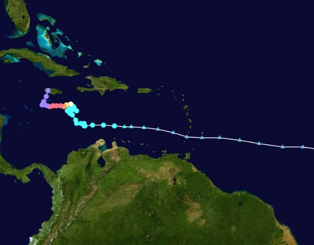
Further complicating the situation is the storm’s diminished velocity, currently measured at a mere three miles per hour. Projections indicate that Melissa is poised to deposit between 20 and 25 inches of rainfall across certain regions of Jamaica.

“This presents a scenario of persistent and continuous exposure to a hazardous environment,” stated Jill Trepanier, an expert in hurricane climatology at Louisiana State University, in her conversation with AFP.
“This could manifest as prolonged inundation, excessive rainfall over an extended duration that overwhelms watershed capacities, or sustained high-velocity winds that exceed the resilience of most infrastructure. It could also be a confluence of all these factors.”
Trepanier is the author of a research paper published last year focusing on so-called “stalling storms,” which concluded that such occurrences in the Caribbean typically manifest in October, often in proximity to coastal areas.
Under normal circumstances, stationary storms tend to dissipate. This is because they draw colder water from deeper oceanic layers and are subjected to turbulent atmospheric wind patterns that promote their disintegration.
What distinguishes Melissa is its ability to remain stationary while simultaneously intensifying – an indication that the ocean water was sufficiently warm, and possessed adequate thermal depth, to counteract the usual self-destructive feedback mechanisms.
“It represents a rather alarming circumstance,” commented Trepanier.
James Kossin, a former NOAA climatologist with an extensive publication record on this subject, affirmed that empirical data unequivocally demonstrate an upward trend in the frequency of stalling storms.
A potential contributing factor is “Arctic amplification,” wherein global warming diminishes the temperature gradient between equatorial and polar regions, consequently weakening the steering currents that typically guide storms, much like a “cork in a stream.” Nevertheless, further investigation is necessitated to establish a definitive causal connection.
Trepanier further emphasized the critical importance of comprehending the human and ecological dimensions of such events, in addition to their physical dynamics, given the varied human responses to perceived risk.
Given Jamaica’s rugged, mountainous topography, the intense rainfall could precipitate landslides. Concurrently, substantial damage to hotel infrastructure could have long-lasting detrimental effects on the nation’s tourism-dependent economy, she cautioned.
