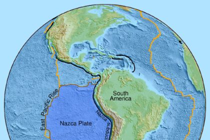
Utilizing advanced 3D seismic imaging, researchers have identified a substantial subterranean reservoir of water located 3.2 kilometers (2 miles) beneath the seabed off the coast of New Zealand. This significant water accumulation is hypothesized to be mitigating seismic activity along a major fault zone that impacts the nation’s North Island. This particular fault is recognized for generating seismic events characterized by slow movement, referred to as slow slip events, which can dissipate accumulated tectonic stress gradually over extended periods, spanning days to weeks.

3D seismic imaging and ocean drilling at the Hikurangi margin reveal a widespread and previously unknown fluid reservoir within the extensively hydrated (up to 47 vol % water) volcanic upper crust of the subducting Hikurangi Plateau large igneous province. Image credit: Gase et al., doi: 10.1126/sciadv.adh0150.
“A significant number of slow slip earthquakes are believed to have a connection with buried water deposits,” stated Dr. Andrew Gase, a postdoctoral researcher affiliated with the University of Texas.
“However, until this discovery, there was a lack of direct geological evidence to support the existence of such an extensive water reservoir in proximity to this specific New Zealand fault.”
“Our current imaging capabilities do not allow us to probe deep enough to determine the precise influence on the fault’s behavior, but we have observed that the volume of water infiltrating this region significantly exceeds typical levels.”
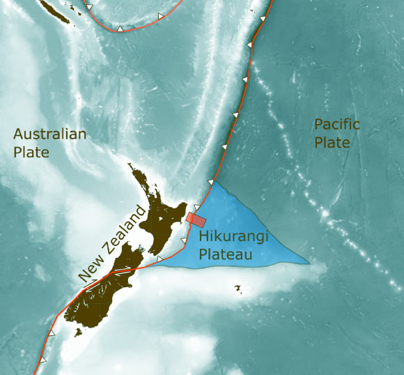
The geographical area where Dr. Gase and his research team located this water body is part of an expansive volcanic province that originated from a colossal plume of lava, comparable in size to the United States, which erupted onto the Pacific Ocean’s surface approximately 125 million years ago.
This cataclysmic event stands as one of recorded history’s most formidable volcanic eruptions, persisting for several million years.
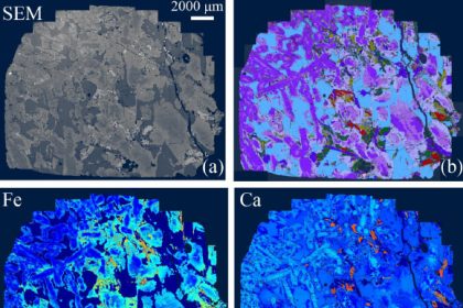
The investigators employed seismic scanning techniques to construct a three-dimensional representation of the ancient volcanic plateau. Within this detailed mapping, they identified thick, stratified sedimentary layers enveloping subterranean volcanoes.
Subsequent laboratory analyses were conducted on core samples extracted from the volcanic rock, revealing that water constituted nearly half of the rock’s total volume.

The seismic image of the Hikurangi Plateau reveals details about the Earth’s interior and what it’s made of. The blue-green layer under the yellow line shows water buried within rocks Image credit: Gase et al., doi: 10.1126/sciadv.adh0150.
“Standard oceanic crust, after reaching an age of approximately 7 to 10 million years, typically contains considerably less water,” commented Dr. Gase.
“Remarkably, the oceanic crust examined in the seismic scans, which was ten times older, retained a significantly higher moisture content.”
“The shallow marine environments where these volcanic eruptions occurred led to the erosion of some volcanic structures, transforming them into porous, fractured rock formations that effectively stored water, akin to an aquifer, as they were subsequently buried. With the passage of time, the rock and its constituent fragments underwent a metamorphosis into clay, thereby entrapping even greater quantities of water.”
This finding holds considerable significance, as scientists theorize that subterranean water pressure may play a critical role in establishing the conditions conducive to the release of tectonic stress through slow slip earthquakes.
Typically, this phenomenon occurs when water-rich sedimentary layers are incorporated into a fault zone, effectively trapping the water beneath the surface. However, the fault in question off New Zealand exhibits a scarcity of these conventional oceanic sediments.
Instead, the research team posits that the ancient volcanic formations and their subsequently altered rock materials—now in the form of clays—are instrumental in transporting substantial volumes of water downward as they are subducted along the fault line.
“These discoveries suggest that analogous geological circumstances might be present along other earthquake fault lines globally,” remarked Professor Demian Saffer, a researcher at the University of Texas.
“This serves as a potent illustration of the correlation between subsurface fluid dynamics and the mechanisms governing tectonic fault displacement, including earthquake behavior.”
“This is a phenomenon that has been inferred from laboratory experiments and is predicted by certain computational models; however, empirical field studies that validate this at the scale of a tectonic plate are exceedingly rare.”
The research endeavor has been published in the esteemed journal Science Advances.
_____
Andrew C. Gase et al. 2023. Subducting volcaniclastic-rich upper crust supplies fluids for shallow megathrust and slow slip. Science Advances 9 (33); doi: 10.1126/sciadv.adh0150