Submarine canyons, which are extensive, profound depressions found on the majority of Earth’s continental margins, are prevalent features in Antarctica. These geological formations play a crucial role in shaping oceanographic processes and have considerable ramifications for global climate patterns and oceanic circulation. The current understanding of their oceanographic, climatic, geological, and ecological importance is constrained by the limitations in the detail, precision, and scope of existing canyon inventories. In a recent investigation, researchers affiliated with University College Cork and the Universitat de Barcelona undertook the task of compiling the most comprehensive catalog of Antarctic submarine canyons and gullies to date. They successfully pinpointed 332 distinct drainage networks, comprising 3,291 stream segments, a figure nearly five times greater than the number of canyons previously documented.
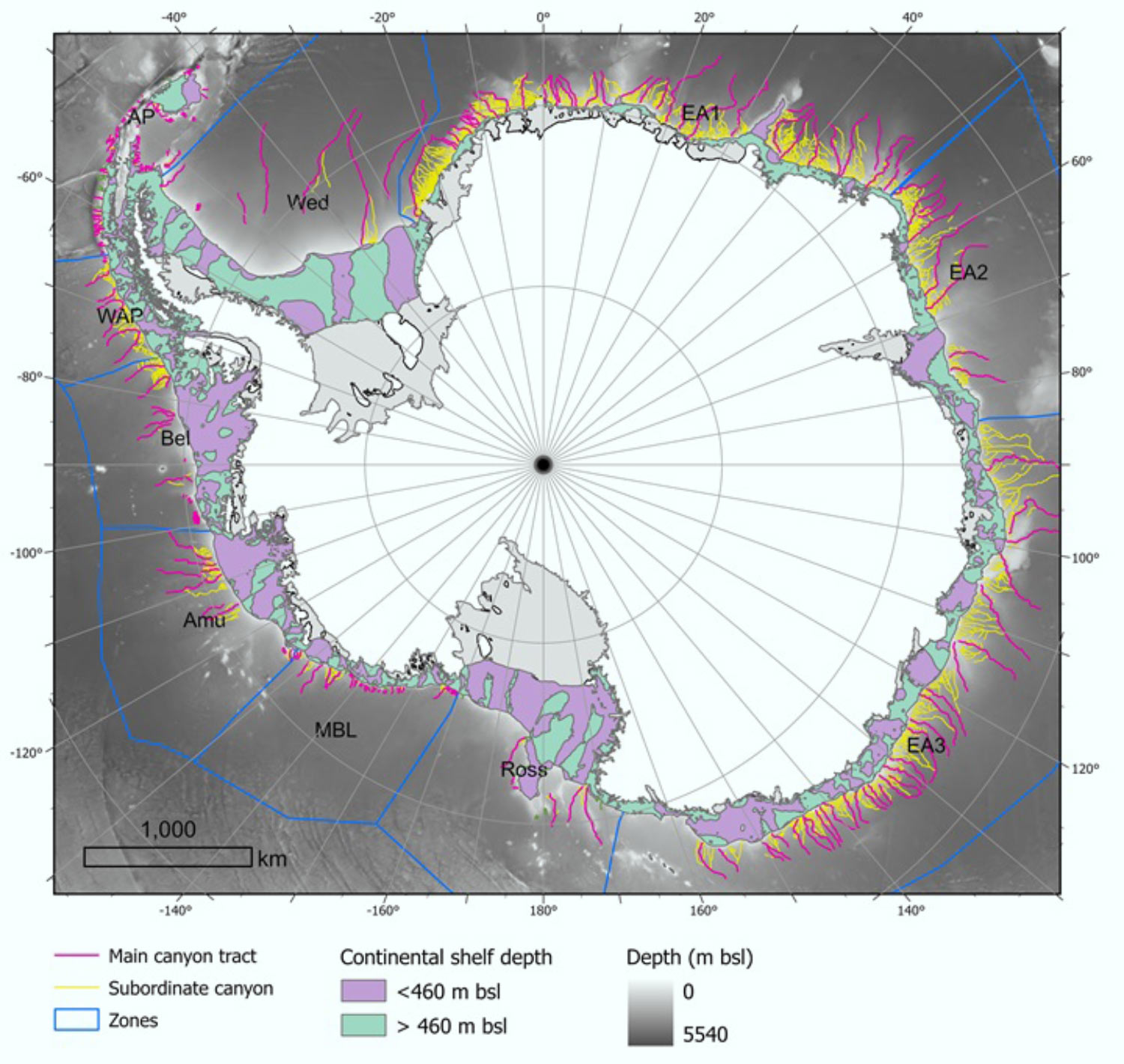
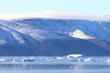
This map illustrates 332 networks of submarine canyons situated on the Antarctic continent’s seabed. Image attribution: Riccardo Arosio & David Amblas, doi: 10.1016/j.margeo.2025.107608.
Submarine canyons represent prevalent geomorphic structures observed across all continental margins.
These are characterized by steep inclines, typically exhibiting a V-shaped profile with relatively narrow and meandering configurations, marked by rugged slopes. They originate at the continental shelf’s edge or along the continental slope and extend to the continental rise or the abyssal plain.
Submarine gullies, defined as confined channels typically under 10 kilometers in length, usually on the order of tens of meters in depth, and linear in their aerial view, are frequently discovered adjacent to or within canyon systems on the continental slope.
These underwater canyons facilitate the transfer of sediments and nutrients from coastal areas to deeper oceanic zones, thereby bridging shallow and deep water environments and fostering biodiversity-rich ecosystems.
While scientists have identified approximately 10,000 submarine canyons globally, the actual total is presumed to be significantly higher given that only 27% of the Earth’s seafloor has been meticulously mapped at high resolution.
Despite their substantial ecological, oceanographic, and geological value, submarine canyons remain largely uninvestigated, particularly within the polar regions.
“Similar to their Arctic counterparts, Antarctic submarine canyons bear resemblance to canyons found in other global locations,” indicated Dr. David Amblàs, a researcher at the Universitat de Barcelona.
“However, they tend to exhibit greater dimensions and depth due to the prolonged influence of polar ice and the colossal quantities of sediment transported by glaciers to the continental shelf.”
For their research, the investigators utilized Version 2 of the International Bathymetric Chart of the Southern Ocean (IBCSO v2), which constitutes the most comprehensive and detailed map of the seafloor in this particular region.
This chart incorporates new high-resolution bathymetric data and employs a semi-automated methodology developed by the authors for the identification and analysis of canyons.
Collectively, it delineates 15 morphometric parameters that reveal pronounced distinctions between canyons located in East and West Antarctica.
“Certain submarine canyons we examined descend to depths exceeding 4,000 meters,” stated Dr. Amblàs.
“The most striking examples of these are situated in East Antarctica, an area distinguished by intricate, dendritic canyon systems.”
“These systems frequently commence with multiple canyon heads situated proximal to the continental shelf’s margin, subsequently converging into a solitary principal channel that traverses the steep gradients of the continental slope and descends into the deep ocean.”
“It was particularly illuminating to observe the disparities between the canyons in the two primary Antarctic regions, as this aspect had not been previously documented,” observed Dr. Riccardo Arosio, a researcher at University College Cork.
“Canyons in East Antarctica are more elaborate and exhibit a branched structure, frequently forming extensive canyon-channel systems characterized by typical U-shaped cross-sections.”
“This morphology suggests a protracted development under persistent glacial activity, with a more significant impact from both erosional and depositional sedimentary processes.”
“Conversely, the canyons in West Antarctica are characterized by shorter and steeper profiles, featuring V-shaped cross-sections.”
“This morphological divergence lends credence to the hypothesis that the East Antarctic Ice Sheet originated at an earlier epoch and has undergone a more sustained period of development,” explained Dr. Amblàs.
“While this notion had been previously posited by studies of sedimentary records, it had not yet been substantiated through large-scale seafloor geomorphology.”
“Leveraging the enhanced resolution of the new bathymetric database—offering 500-meter pixels compared to the 1-2 kilometer pixels of preceding maps—we were able to reliably employ semi-automated techniques for the identification, profiling, and analysis of submarine canyons,” Dr. Arosio remarked.
“The efficacy of this study is derived from its integration of diverse methodologies, previously employed individually, into a cohesive and systematic protocol.”
“Furthermore, we developed a GIS software script that facilitates the calculation of a wide array of canyon-specific morphometric parameters with remarkable ease and speed.”
The team’s research is published in the journal Marine Geology.
_____
Riccardo Arosio & David Amblas. 2025. The geomorphometry of Antarctic submarine canyons. Marine Geology 488: 107608; doi: 10.1016/j.margeo.2025.107608