A comprehensive aerial survey, conducted using high-resolution Unmanned Aerial Vehicles (UAVs), of Dmanisis Gora, a massive Bronze-Age fortified settlement in Georgia located in the South Caucasus, has illuminated the considerable scale of its expansive outer defensive structures and associated habitation areas. This discovered complex presents a rarity in regional documentation. The remarkable magnitude of Dmanisis Gora offers novel perspectives for understanding population aggregation models, not only within Eurasia but also on a global scale.

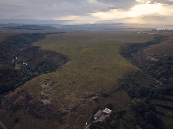
Aerial photograph of the Dmanisis Gora archaeological site, illustrating its strategic position where two gorges converge; the foreground reveals excavations from the 2023 season within the inner citadel. Credit: Nathaniel Erb-Satullo.
The emergence of fortified settlements in the South Caucasus between approximately 1500 and 500 BCE marked a significant and unprecedented advancement in the region’s prehistoric development.
The Caucasus region, situated at the nexus of Europe, the Eurasian steppe, and the Middle East, possesses a profound historical legacy as a vibrant cultural intersection, nurturing distinct indigenous identities.
In a recent scholarly endeavor, archaeologists directed their attention to Dmanisis Gora, a fortress-settlement in Georgia spanning an impressive 60-80 hectares, renowned for its exceptional state of preservation and substantial size.
“The Dmanisis Gora fortification complex encompasses a core citadel with dual defensive ramparts, along with a substantially larger peripheral enclosure featuring additional protective works,” stated Dr. Nathaniel Erb-Satullo, affiliated with the Cranfield Forensic Institute at Cranfield University, and his research collaborators.
“The natural defenses are complemented by two precipitous gorges, some sections of which descend to a depth of 60 meters, augmenting the inherent defensive capabilities of the site.”
“Previous examinations had indicated the presence of an unusually extensive outer perimeter at the location, yet a systematic cartographic survey had not been undertaken.”
The research team employed a DJI Phantom 4 RTK drone, a sophisticated instrument capable of achieving sub-2-centimeter relative positional accuracy and capturing aerial imagery of exceptionally fine detail.
To meticulously delineate a precise map of human-constructed features, each identified element within the aerial imagery underwent rigorous verification to ensure accurate classification.
To ascertain the evolutionary trajectory of the site’s landscape, the generated orthophotos were juxtaposed with photographic records dating back five decades, captured by a Cold War-era spy satellite whose imagery was declassified in 2013.
This comparative analysis provided crucial insights for the researchers, enabling them to differentiate contemporary features from older ones.
Furthermore, this process allowed the team to evaluate the extent to which certain areas of the ancient settlement had been impacted by contemporary agricultural activities.
All collected datasets were integrated within Geographic Information System (GIS) software, facilitating the identification of discernible patterns and transformations within the landscape.
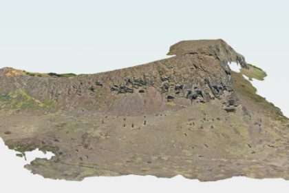
“The drone captured close to 11,000 images, which were subsequently stitched together utilizing advanced software to generate high-resolution digital elevation models and orthophotos—composite images depicting each point from a direct overhead perspective,” explained Dr. Erb-Satullo.
The findings produced by the research team indicated that the Dmanisis Gora site was more than 40 times larger than initially estimated, encompassing a significant outer settlement protected by a 1-kilometer-long defensive wall.
“The utilization of drones has afforded us an unparalleled understanding of the site’s importance and has enabled its documentation in a manner that would be practically infeasible through terrestrial exploration,” asserted Dr. Erb-Satullo.
“Dmanisis Gora represents not only a discovery of profound importance for the South Caucasus region but also carries broader implications for understanding the diversity in the architectural configurations of large-scale settlements and the processes underlying their development.”
“Our hypothesis suggests that Dmanisis Gora experienced expansion due to its interactions with nomadic pastoralist communities, and its extensive outer settlement likely underwent seasonal fluctuations in size.”
“With the site now thoroughly mapped, subsequent investigations are poised to yield valuable insights into aspects such as population density and intensity, livestock migratory patterns, and agricultural methodologies, among other critical areas.”
The scientific paper detailing this research was formally published in the esteemed journal Antiquity.
_____
Nathaniel L. Erb-Satullo et al. Mega-fortresses in the South Caucasus: new data from southern Georgia. Antiquity, published online January 8, 2025; doi: 10.15184/aqy.2024.197