
MEXICO CITY (AP) – New satellite imagery unveiled this week by NASA reveals that Mexico City is experiencing a significant rate of subsidence, sinking by almost 10 inches (approximately 25 centimeters) annually. This alarming pace positions the Mexican capital among the globe’s most rapidly subsiding urban centers.
As one of the planet’s most expansive and densely populated metropolitan areas, spanning roughly 3,000 square miles (about 7,800 square kilometers) and home to approximately 22 million inhabitants, the Mexican capital and its contiguous urban sprawl were established on the geological foundation of an ancient lakebed.
Historically, numerous thoroughfares in the city’s core once served as waterways, a heritage that persists in the semi-rural peripheries of the region where traditional practices endure.
Aggressive extraction of groundwater, coupled with extensive urban expansion, has led to a drastic depletion of the underlying aquifer. Consequently, Mexico City has been undergoing a process of sinking for over a century. This phenomenon has caused many historical structures and older edifices, such as the Metropolitan Cathedral which commenced construction in 1573, to exhibit a noticeable tilt.
The diminution of the aquifer’s capacity has also exacerbated a persistent water scarcity issue, a situation that is projected to intensify.
“This situation inflicts damage upon crucial components of Mexico City’s infrastructure, including the subterranean transit network, the sewage and drainage systems, the distribution of potable water, residential buildings, and the road network,” stated Enrique Cabral, a geophysics researcher affiliated with the National Autonomous University of Mexico.
“The scale of this challenge is immense.”
The rate at which Mexico City is descending is so pronounced that the subsidence is discernible even from orbital vantage points.
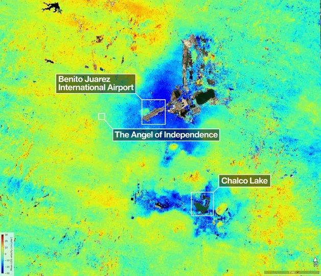
According to a recently published report from NASA, certain sectors of the city are experiencing subsidence at an average velocity of 0.78 inches (2 centimeters) each month. This includes critical locations like the primary international airport and the prominent landmark colloquially referred to as the Angel of Independence.
Cumulatively, this equates to an annual subsidence rate of approximately 9.5 inches (24 centimeters). Data compiled by Cabral indicates that in less than a century, the land has dropped by over 39 feet (12 meters).
“We are observing one of the most rapid rates of land subsidence globally,” he remarked.
The estimations provided by NASA are derived from precise measurements captured between October 2025 and January 2026 utilizing the advanced NISAR satellite. This sophisticated instrument, a collaborative endeavor between NASA and the Indian Space Research Organization, possesses the capability to monitor real-time alterations on the Earth’s surface.
NISAR scientist Paul Rosen explained that by meticulously documenting terrestrial details from space, the project also “provides insights into subterranean processes.”
“Essentially, it serves as a comprehensive record of these urban transformations,” Rosen elaborated.
He further added, “The full magnitude of the predicament becomes evident.”
The research team anticipates that, over time, their capabilities will advance to enable more granular analysis of specific urban zones, potentially achieving measurements on an individual building basis in the future.
On a broader scale, scientists envision the application of this technology worldwide for monitoring a diverse range of phenomena, including natural catastrophes, shifts in geological fault lines, the impacts of climate change in sensitive regions such as Antarctica, and numerous other environmental indicators.
Rosen highlighted its potential utility in enhancing early warning systems, empowering scientists to alert governmental bodies to impending threats, such as the imperative for evacuations during volcanic eruptions.
For Mexico City, this technological advancement represents a significant leap forward in the investigation of the subsidence issue and the implementation of strategies to mitigate its most severe consequences, according to Cabral.
For many years, governmental efforts to address this problem were minimal, largely confined to reinforcing foundations beneath significant monuments like the cathedral.
However, in response to recent escalations of the water crisis, Cabral noted that authorities have begun allocating resources to support further research initiatives.
The data generated by the NISAR satellite, along with its associated information, will be instrumental for both scientific experts and public officials as they formulate strategies to confront this pressing issue.
“To effectively manage and mitigate the long-term implications of this situation,” Cabral stated, “the foundational step is achieving a comprehensive understanding.”