While the construction of artificial islands might evoke modern images of Dubai and China, Scotland boasts a long history of such endeavors, dating back thousands of years.
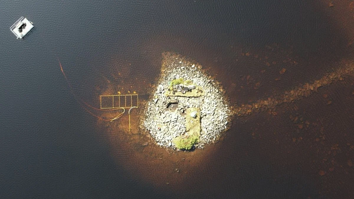
Evidence uncovered in Loch Bhorgastail on the Isle of Lewis reveals that a particular structure, known as a ‘crannog,’ was initially erected over five millennia ago by prehistoric peoples during the Late Neolithic period.
Through the application of contemporary technologies, researchers have now identified the substantial wooden and stone substructures of the Loch Bhorgastail crannog, solidified many centuries ago.
“Crannogs represent diminutive, man-made islands, typically originating thousands of years in the past,” states archaeologist Stephanie Blankshein from the University of Southampton in the United Kingdom.
“A considerable number of these structures exist within Scotland’s lochs, with many yet to undergo exploration or discovery.”
“Although crannogs were traditionally believed to have been constructed, utilized, and subsequently modified primarily from the Iron Age through the post-medieval era, current findings indicate that some were first established considerably earlier, during the Neolithic period, between 3800 and 3300 BCE.”
The task of accurately dating the foundations of the Loch Bhorgastail crannog presented significant challenges for the investigating archaeologists.
While the presence of a stone layer forming the island’s base and fragments of Neolithic pottery—chipped pieces of bowls and jars—scattered in the adjacent waters were known, precise dating remained elusive.
However, recent technological advancements have permitted a more granular examination of the site.
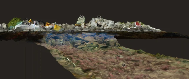
The research team employed a methodology known as stereophotogrammetry. This technique facilitates the reconstruction of a three-dimensional model of an object by synthesizing numerous photographs captured from various viewpoints surrounding it.
Typically, archaeologists utilize drones for this purpose, as the drone’s flight path, and consequently the camera’s trajectory, can be readily mapped using global satellite navigation systems (GNSS). This mapping is crucial for accurately stitching together the resultant 3D imagery.
Nonetheless, a substantial number of the critical features of the Loch Bhorgastail crannog lie submerged in shallow, turbid water. Such conditions are suboptimal for the high-quality imagery required for photogrammetry, and the GNSS tracking is compromised because the radio signals essential for its operation do not penetrate water effectively.
“Obscuring factors such as fine sediment, agitated water conditions, floating vegetation, and optical distortions caused by light refraction or reflection all impede clear underwater imaging,” explains maritime archaeologist Fraser Sturt from the University of Southampton.
“While photogrammetry performs exceptionally well in deep water, it encounters significant limitations at depths below one meter. This particular challenge has long been a source of considerable frustration for archaeologists.”
To surmount this hurdle, a diver equipped with two wide-angle, low-light cameras mounted on a single apparatus navigated a meticulously planned underwater route.
This innovative approach achieved a level of positional accuracy equivalent to that obtained with aerial drones, while simultaneously yielding significantly clearer visual data from beneath the water’s surface. An interactive 3D model of the site is available for exploration below.
Loch Bhorgastail crannog 2021 – complete model by Islands of Stone on Sketchfab
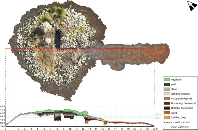
The creation of this and similar models was instrumental in planning subsequent, more traditional archaeological fieldwork at the site. This included meticulous excavation of the crannog’s ancient foundations and the radiocarbon dating of the recovered materials.
“As the excavation progressed, it became abundantly clear that the terrestrial and submerged components constituted a singular, continuous structure that spanned both environments and could not be analyzed in isolation,” the authors Sturt and Blankshein, along with their team, elaborate in a peer-reviewed publication.
Beneath the island’s stone cap, evidence of wooden foundations dating back millennia was unearthed, vividly depicted in the integrated photogrammetry model through a trench excavated below the waterline.
The prehistoric inhabitants responsible for this crannog initially constructed a circular wooden platform, approximately 23 meters (75 feet) in diameter, around five thousand years ago. This platform was subsequently covered with brushwood.
Approximately two millennia later, additional layers of brushwood were added, and the structure was further fortified with stone. At some indeterminate point, a stone causeway was also incorporated, establishing a connection between the crannog and the adjacent loch shore.
This research provides compelling validation for the efficacy of a novel technique for surveying underwater archaeological sites with a degree of accuracy comparable to that achieved for terrestrial locations.
Furthermore, it serves as a remarkable testament to humanity’s millennia-long engagement with landscape engineering.
While the precise function of this particular crannog remains a subject of speculation, the surrounding accumulation of domestic debris suggests that it served the needs of its inhabitants effectively throughout its long history.