Have you ever contemplated the whereabouts of your current locale within the ancient supercontinent of Pangaea? Now, this curiosity can be satisfied personally.
A collective of Earth scientists has recently unveiled an enhancement to Paleolatitude.org, a sophisticated instrument designed to illustrate the dynamic latitudinal shifts of any terrestrial point across a span of 320 million years, a testament to profound continental displacement.
This development holds the potential to reframe existing geological and paleontological records, affording them an entirely novel perspective. A fossilized remnant can thus be traced not only through temporal progression but also through spatial relocation.
Consider a quarry situated near Winterswijk in the Netherlands, which harbors fossilized remains of flora and fauna dating back 245 million years.
All available evidence robustly indicates that these ancient lifeforms thrived in an environment analogous to that of the contemporary Persian Gulf, rather than the climate characteristic of present-day eastern Europe.
This deviation was not solely attributable to a universally warmer global temperature during that epoch.
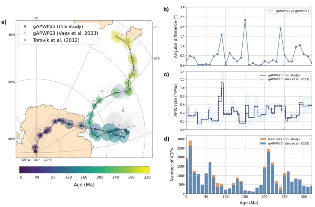
The Utrecht Paleogeography Model, serving as the foundational framework for this new utility, has corroborated that approximately 245 million years ago, the Winterswijk fossils occupied a latitude comparable to that of modern-day Arabia, an illustration vividly presented in the accompanying video, where the Netherlands is highlighted in pink.
This most recent iteration introduces refined details and enhanced user-centric functionalities to the Paleolatitude.org calculator, which was initially introduced roughly a decade in the past.
“With the implementation of the new model, our confidence has significantly increased, and our comprehension of biodiversity is evolving from a strictly chronological, or one-dimensional, view to a more comprehensive, three-dimensional paradigm that incorporates spatial dimensions as well,” elucidates co-author Emilia Jarochowska, a paleontologist affiliated with Utrecht University.
“This advancement empowers us to derive critical insights into the adaptability and persistence of biodiversity in the current era.”
The updated tool incorporates a global paleogeographic model that spans an extensive 320-million-year period, delineating geographical formations that are now compressed within orogenic (mountainous) zones.
Furthermore, it brings paleomagnetic models into alignment with contemporary data, acknowledging that not only did continents migrate over geological time, but the Earth’s magnetic poles also underwent significant shifts.
The newly launched web platform provides users with the capability to export datasets and visual representations, and even to upload their proprietary information for the computation of paleolatitude on a large scale (a task best left to seasoned researchers).
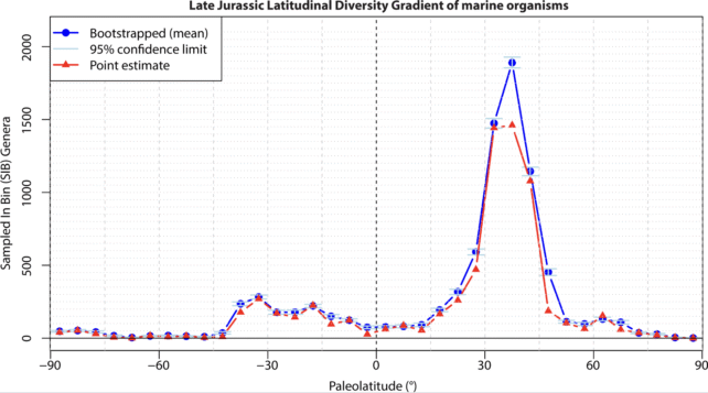
To demonstrably showcase the capabilities of the novel tool, the research team undertook the calculation of a biodiversity gradient for the Late Jurassic period, based on the historical latitudes of landmasses that have subsequently undergone considerable repositioning.
Utilizing a comprehensive dataset comprising approximately 34,000 marine fossils from the Upper Jurassic epoch, the research group successfully reverted the temporal and spatial context of the fossil discovery locations to their original latitudes at the time of the organisms’ demise.
Not only were the researchers adept at mapping the specific latitudes exhibiting the highest genus-level diversity, but they were also capable of applying statistical refinements, including estimations of uncertainty and bootstrapping techniques, to the data, thereby yielding a more scientifically robust conclusion.
“This enables us, for instance, to illustrate the global biodiversity fluctuations during and in the aftermath of past mass extinction events, perhaps triggered by rapid planetary warming or cooling,” states Jarochowska.
“Which latitudinal zones became uninhabitable most swiftly, and which provided vital refuges? What migratory patterns did species follow, which ones adapted to changing circumstances, and which ultimately succumbed to extinction?”
The research consortium has articulated intentions to extend the application of their model further back into Earth’s historical timeline, with the ultimate aim of encompassing the Cambrian explosion, which occurred approximately 550 million years ago.
However, for the present moment, you are invited to explore the latitudinal journey of your own backyard (or any other location that sparks your interest) by simply inputting the coordinates on this platform here, and charting its historical trajectory through the eons.